Collection Highlights
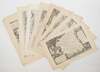
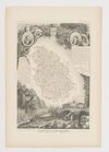
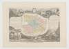
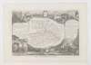
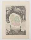
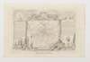
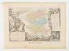
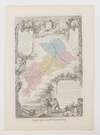
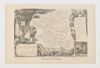
Collection of 1600 maps from the ATLAS NATIONAL ILLUSTRE DES 86 DEPARTEMENTS ET DES POSSESSIONS DE LA FRANCE


Collection of 1600 maps from the ATLAS NATIONAL ILLUSTRE DES 86 DEPARTEMENTS ET DES POSSESSIONS DE LA FRANCE
Place of Publication: Paris
Publisher: Amable Combette; Pelissier
Publication Date: 1845-1869
More Details
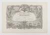
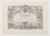
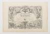
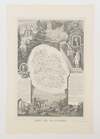
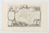
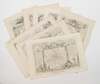
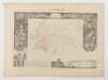
A collection of 1600 maps disbound from copies of multiple editions of the Atlas National Illustre des 86 Departements et des Possessions de la France. The editions represented here were published between 1845 and 1869 in Paris by Amable Combette (all editions between 1845 and 1858) and Pelissier (all editions between 1859 and 1869). The magnum opus of French cartographer Victor Levasseur (1795-1862), the maps of the Atlas National Illustre are particularly well-known for their ornately engraved borders. The maps are in good condition with mild to moderate age toning and tearing to edges where they were disbound. The collection includes multiple copies of the maps of many Departements. Thirteen maps included in this collection are from French language sources other than the Atlas National Illustre.
Number of maps by Departement:
Title page: 26
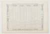
Statistical Table: 7
Ain: 26
Aisne: 27
Algerie: 21
Allier: 27
Alpes Maritimes: 2
Ardeche: 29
Ardennes: 23
Ariege: 21
Aube: 16
Aude: 9
Aveyron: 14
Bas Rhin: 3
Basses Pyrenees: 2
Basses-Alpes: 26
Bes du Rhone: 3
Calvados: 10
Cantal: 16
Charente Infre: 15
Charente: 4
Cher: 12
Colonies Francaise: 34
Correze: 23
Corse: 1
Cote d’Or: 2
Cotes du Nord: 25
Creuse: 31
Deux Sevres: 29
Dordogne: 13
Doubs: 19
Drome: 20
Eure et Loir: 23
Eure: 9
Finistere: 2
France: 7
Gard: 20
Gers: 21
Haut Rhin: 5
Haute Alpes: 12
Haute Garonne: 13
Haute Loire: 28
Haute Marne: 27
Haute Pyrenees: 2
Haute Saone: 32
Haute Savoie: 4
Haute Vienne: 19
Herault: 9
Ile de la Reunion: 28
Ille et Vilaine: 19
Indre et Loire: 12
Indre: 24
Isere: 16
Jura: 15
Landes: 19
Loir et Cher: 22
Loire Infre: 12
Loire: 7
Loiret Infre: 1
Loiret: 14
Lot et Garonne: 23
Lot: 18
Lozere: 33
Lyonne: 15
Maine et Loire: 19
Manche: 1
Marne: 1
Mayenne: 29
Meurthe: 13
Meuse: 26
Morbihan: 16
Moselle: 19
Nievre: 21
Nord: 26
Oceanie: 1
Oise: 32
Orne: 22
Pas de Calais: 18
Puy de Dome: 26
Pyrenees Orles: 26
Saone et Loire: 20
Sarthe: 19
Savoie: 7
Seine et Marne: 18
Seine Inferieure: 14
Seine: 2
Somme: 22
Tarn et Garonne: 30
Tarn: 20
Var: 3
Vaucluse: 22
Vendee: 27
Vienne: 15
Vosges: 25
Maps from other sources: 13
JC Consignment. Oversized and extremely heavy lot; additional postage will be necessary. Please inquire for rates before purchase.
Number of maps by Departement:
Title page: 26
Statistical Table: 7
Ain: 26
Aisne: 27
Algerie: 21
Allier: 27
Alpes Maritimes: 2
Ardeche: 29
Ardennes: 23
Ariege: 21
Aube: 16
Aude: 9
Aveyron: 14
Bas Rhin: 3
Basses Pyrenees: 2
Basses-Alpes: 26
Bes du Rhone: 3
Calvados: 10
Cantal: 16
Charente Infre: 15
Charente: 4
Cher: 12
Colonies Francaise: 34
Correze: 23
Corse: 1
Cote d’Or: 2
Cotes du Nord: 25
Creuse: 31
Deux Sevres: 29
Dordogne: 13
Doubs: 19
Drome: 20
Eure et Loir: 23
Eure: 9
Finistere: 2
France: 7
Gard: 20
Gers: 21
Haut Rhin: 5
Haute Alpes: 12
Haute Garonne: 13
Haute Loire: 28
Haute Marne: 27
Haute Pyrenees: 2
Haute Saone: 32
Haute Savoie: 4
Haute Vienne: 19
Herault: 9
Ile de la Reunion: 28
Ille et Vilaine: 19
Indre et Loire: 12
Indre: 24
Isere: 16
Jura: 15
Landes: 19
Loir et Cher: 22
Loire Infre: 12
Loire: 7
Loiret Infre: 1
Loiret: 14
Lot et Garonne: 23
Lot: 18
Lozere: 33
Lyonne: 15
Maine et Loire: 19
Manche: 1
Marne: 1
Mayenne: 29
Meurthe: 13
Meuse: 26
Morbihan: 16
Moselle: 19
Nievre: 21
Nord: 26
Oceanie: 1
Oise: 32
Orne: 22
Pas de Calais: 18
Puy de Dome: 26
Pyrenees Orles: 26
Saone et Loire: 20
Sarthe: 19
Savoie: 7
Seine et Marne: 18
Seine Inferieure: 14
Seine: 2
Somme: 22
Tarn et Garonne: 30
Tarn: 20
Var: 3
Vaucluse: 22
Vendee: 27
Vienne: 15
Vosges: 25
Maps from other sources: 13
JC Consignment. Oversized and extremely heavy lot; additional postage will be necessary. Please inquire for rates before purchase.
Item:
1375010